Wednesday, March 30, 2011

Carlsbad

We left the scenic surroundings of the Texas Mountains yesterday and headed north through miles and miles of vast nothingness into New Mexico. (We followed that fifth wheel most of the way!)

The first real town we passed through after crossing the state line was Loving, which made us think of our friends Cindy and Rick. This one's for you two. Cheers!

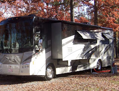
We made our way through the town of Carlsbad to the KOA several miles north of town. The sites are spacious and flat. Bullwinkle especially likes being level, for a change.

Our primary purpose for stopping in Carlsbad was to visit Carlsbad Caverns National Park, which is about 20 miles south of town. After making the turn off the highway and toward the caverns, we were pleased to see something scenic once again. (Yes, when you are in southeast New Mexico, this is scenic!)

At the visitor's center, we flashed our annual park pass and picked up two audio tours. (We highly recommend!) When the ranger asked if we wanted to walk or ride down, we told him we'd rather hike. So, he pointed us toward the trailhead. Along the way we saw several warnings about the 1.25-mile hike ahead of us.

We came prepared for this downhill hike and didn't have any doubts that we could make it safely. But, as the warnings became more serious, we started to wonder!

As experienced hikers, we really weren't worried. This is the last sign you see before you stop and check-in with a ranger who gives you clearance to move on. He looked us over and gave us a few last minute words of advice. With that, we were ready to go.

Just outside the Natural Entrance is a large amphitheater where visitors come for the nightly bat flight. Each evening at dusk, thousands of Mexican free-tailed bats fly from out of the entrance to the cave. Lucky for one of us, this nightly show doesn't begin until late Spring. Today we would not be sharing the cave with any bats!

Now would be a good time to tell you that the same one of us who is glad there are no bats here is really not terribly fond of caves. (And, it was my idea to come here!) With camera in hand, and Paul leading the way, I began the 750-foot decent while keeping a sharp eye back on the entrance and the great outdoors.

Before long, we entered what is called "The Twilight Zone". In this space, there's very little daylight still entering the cave. An eerie cloud of mist covers the entrance, which suddenly seemed very far away.

We stepped ahead in the darkness and were glad to see plenty of lights to show us the way. Though the trail was steep in places, there were helpful handrails along the way. For the one of us who isn't too fond of caves, the trail was quite spacious. This was one of the most narrow spots along the way. We (er, I) never felt closed in.

Along the way, I took hundreds of really bad pictures. Because we were hiking (and you saw all of those warnings!), we left our nifty Nikon and tripod at home. So, I did the best I could with my little "point and shoot" and wasted a bunch of zeros and ones. A few did come out well enough to give you a taste of our underground hike.

Our audio tour provided lots of interesting and helpful background about the wonders of the cavern. Now we can remember that stalactites "grow" from the ceiling and stalagmites live on the floor. When these two meet somewhere in the middle, they become a column. The audio tour also answered key questions, such as "Do these things ever fall?" and "Is there plenty of fresh air in here?" just about the time one of us was wondering about such things. (The answers: No and Yes.)

The nice paved trail we were hiking on followed the original explorer's route into the cave. The trail, of course, is a relatively recent addition. Early visitors to the park were lowered into the cave in some kind of cabled contraption, and then walked down these steep wooden stairs. I much prefer the route we took today!

The cave decorations, as they are called, didn't photograph well but they were amazing. These kernel-like decorations are aptly referred to as "popcorn".

When we reached the end of the Natural Entrance trail, things leveled out a bit and we made our way along the 1.25-mile trail that circles the Big Room. This 8.2 acre "room" is highly decorated and immense.

This wire ladder was used by a National Geographic team in 1924 to explore a lower cave. We're not planning to be a part of any National Geographic teams any time soon!

Dripping water is the sound of a live cave. By the sound and feel of our visit today, this cave is very active! The cave pools were fascinating. This rainwater traveled a very long distance to get here.

Here's another feeble attempt to capture a small section of the Big Room.


As we headed toward the elevator, we saw a couple of photographers with fancy cameras and tripods getting a shot of this "Doll's Theater" decoration. I bravely walked up, held my breath, and snapped. It didn't turn out half bad.

With our 2.5-mile awesome hike complete, we hopped on a waiting elevator and took the one-minute ride back to the surface. As we made our way back to the moose, we took in the vast, flat nothingness of southeast New Mexico with new eyes. When you come to Carlsbad, you have to go underground to find the scenic wonders. They are something to see.

And, that's coming from somebody who wasn't fond of caves. Until today.

Monday, March 28, 2011

Fort Davis

We found relief from the heat 120 miles north and nearly 3,000 feet up in quaint and quiet Fort Davis. This tiny town offers spectacular views of unspoiled landscape, rich history and spectacular star gazing. We've enjoyed it all for the last five days.

Our home in Fort Davis has been Davis Mountains State Park. With a 40-foot home on wheels, we're hesitant to visit most state parks. But, everything's bigger in Texas, and there's plenty of room for Bullwinkle here. With full hookups, including cable, this is a mighty fine place to call home for awhile. There's even a lodge with a full-service restaurant. Here in the mountains, many of the RV sites are far from level. With a hefty front to back slope, it took some extra effort to get Bullwinkle level. He looks like he's ready to fly off the hill!

This 2,700 acre park is nestled, as its name implies, in the Davis Mountains. Here's a view of the park from the scenic overlook on Skyline Drive.

The overlook is also the home of a well-named geocache, which Paul searched for. He eventually spotted the cache named "Can You Hear Me Now?" We got a chuckle out of the name because, with no cell service in the campground, this is where campers come to make their calls. Up here the signal is quite strong.

We picked up a few caches in and around Fort Davis. One search brought us here to the historic Dr. Jones house. Unfortunately, the Dr. Jones cache remained elusive.

The last find of our caching afternoon was out in a far corner of a park out on the edge of town. Take a look at that landscape. This is west Texas!

Fort Davis played a major role in the history of the Southwest. This frontier military post was abandoned in 1891. In 1961, the National Park Service named it a Historic Site. Today the 474-acre site features 24 restored buildings and over 100 ruins and foundations and invites visitors to take a step back in early Texas history.

Our first stop at the fort was the Visitor Center, which featured several exhibits detailing the history of the fort.

In the auditorium, we watched an informative orientation video. It did take a little time to get used to seeing Kareem Abdul-Jabbar in Western Wear!

The enlisted men's barracks has been furnished to recreate Summer 1884, when it was occupied by Buffalo Soldiers of Troop H, Tenth Calvary.

The remains of more barracks border the old San Antonio-El Paso Road. From 1854 until 1891 troops stationed at the post protected emigrants, freighters, mail coaches and travelers along the 600-mile stretch.

The remains of the old road look pretty rough, but this mode of transportation is not exactly what we're accustomed to. We'll take our moose over this stagecoach anytime!

The remains of an old brick oven at the ruins of the fort bakery.

With west Texas winds whirling through the Davis Mountains, it didn't take long to dry the laundry on this post.

The post hospital is the latest building undergoing restoration at the fort. The 24-bed facility was normally staffed by a surgeon, steward, soldier-nurses, a cook and a matron. Soldiers suffered mainly from diseases and accidental injuries, not battle wounds.

This framed document in one hospital window lists information about the 17 men who died at the fort.

In the center of the row of officer's quarters sits the Commanding Officer's Quarters. With its tall shade trees and sweeping porch, it's definitely the biggest and nicest house on the block.

The home is furnished to the period 1882-85 when Col. Benjamin H. Grierson and his family resided there. The tasteful appointments brought culture to the wild frontier.

Our two-hour tour of the post was enhanced by the fort's sound program. Throughout the day, recordings of bugle calls and music of the time are broadcast across the site. From Reveille to Taps, various sounds called soldiers to meals, drills and other duties. Hearing them today made it easier to imagine how life may have been protecting the country in the 19th century.

We turned our attention to the skies Saturday night and ventured 13 miles up into the mountains to visit the McDonald Observatory, which is home to one of the world's largest telescopes, the Hobby-Eberly.

Three nights a week, the observatory hosts a "Star Party". We arrived at the visitor's center early to check out the place and catch the sunset before the party.


The sunset wasn't spectacular, but the Star Party certainly was! Spending the evening under a clear, moon-free sky pointing out stars and peeking through several telescopes doesn't make for good blog photos, but it was definitely an evening to remember. If you're in the area, don't miss a chance to see this amazing show.

Tomorrow we'll say farewell to this delightful town. After spending four months in the Great State of Texas, it's time for us to head to somewhere new. More soon from New Mexico.

Tuesday, March 22, 2011

Big Bend: Santa Elena Canyon

The forecast for our last day in Lajitas was - take a guess - HOT! So, that meant one more sunrise drive. We had two things we still wanted to do in Big Bend National Park, but time for just one before things around here started to sizzle. We decided to explore Santa Elena Canyon and save hiking the Window Trail for our next trip, when it’s much cooler! After entering the park, we headed south on the Russ Maxwell Scenic Drive. This 30-mile trek lived up to its name. It was quite scenic.

From an overlook near the end of the scenic drive, we spotted our hiking destination. That “slice” along this ridge is Santa Elena Canyon, a most scenic spot along the border. The towering canyon wall on the left is in Mexico, and its twin on the right sits in the US.

Santa Elena Canyon is seven miles long. The trail along the Rio Grande goes just a bit less than a mile into the canyon.

Our hiker's guidebook warned us that this trail can be impassible due to flooding. That certainly wasn't a problem today as we crossed the dry creek bed with ease.

We spotted this group setting out on a canoe trip. What a gorgeous place to put in! While their travels would be flat, we had some climbing to do on that rise to the right of the river's edge.


The canyon walls provided welcome shade and a gorgeous background for many, many photos.

The trail ends at one of the narrowest places in the canyon. It looks like the canoeists made it through just fine.

Are these ancient petroglyphs on this boulder? Not exactly. It looks like many recent visitors have left their mark at the canyon with a muddy handprint. Remember the Tom Hanks movie Castaway? This rock looked like a crowd of "Wilsons".


Making our exit from the canyon, we took in this stunning view. It captured everything that Big Bend National Park has to offer: the river, the desert and the mountains. We've enjoyed our week here and look forward to returning.

But, like we said, we'll come back when it's cooler.