Friday, May 20, 2011

Arches National Park

John and Sandy joined us for an "orientation" drive through Arches National Park. With cloudy skies and a threat of rain, we decided we'd cover much of the park in the Jeep and save some hikes for a better weather day. The entrance to the park is just three miles or so north of our RV park. Shortly after passing through the gate, our scenic drive delivered. For some 35 miles we were treated to some magnificent scenery.

We stopped for a very short hike around Balanced Rock. It looks like it's held up with mortar. But, it's not!

John and Sandy posed in front of a formation near Balanced Rock that we dubbed "The Hand".

Here's another look at Balanced Rock. The photographer just had to have a little fun!

With more than 2,000 natural arches in this aptly-named park, visitors don't have to go far to see an one or, in this case, two. Lots of folks were crawling around Double Arch when we arrived, but we managed to squeeze in this shot of just Sandy and John in front of the spectacular span.

As we were walking away from Double Arch, the sun came out. Everybody did a quick about face to enjoy this well-lighted and fresh perspective.

These two gateways are called The Windows. That's South Window on the left and North Window on the right.

Along the one-mile loop around The Windows, we enjoyed an up-close look at this grand formation. Paul and Sandy provide some scale. As you can see, these are really big windows!

From the loop we caught a glimpse of Turret Arch. Photographing this formation became an exercise in patience as we waited for climbing visitors to get out of the shot.

The backside of The Windows offered this especially scenic view. The snow-capped La Sal Mountains are an impressive backdrop to the scene. But, today, those beauties were shrouded in clouds.

Fiery Furnace wasn't too fiery today. But, in any light, these 200-feet tall hoodoos are impressive.

We strolled between massive fins on the way to Sand Dune Arch. The fine red sand base made it feel like we were on our way to the beach!

Paul wedged his way into this little passageway for a photo op.

This is today's best view of Sand Dune Arch. It's much bigger than this, of course. This is actually just the very top of the arch. It's the only part that did not have kids climbing on or around it, or rolling down the red sand dune at its base. Nobody in our foursome got a good shot of this arch, but we were all thankful we weren't going to have to do any of the laundry of the families with the tumbling children.


Our last arch of the day was Skyline Arch. With dark clouds looming, we donned rain gear and started the trek to see this hole in the wall that has a relatively recent history of growing. In 1940, a massive section of rock fell away from the arch and doubled the size of the hole to 45-by-69 feet. With a clap of thunder, we decided to head back to Jeep and appreciate this arch from a distance. As raindrops began to fall, we made a quick run through the campground and to the turn around point of this scenic drive.

With plans to return to Arches at least a couple of times during our stay, we headed back to the moose and enjoyed the afternoon rain shower from the comfort of our rolling home.

Tuesday, May 17, 2011

To Utah

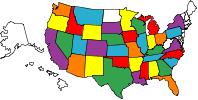
For the longest time, there's been a "hole" in the left side of Bullwinkle's travel map. Bullwinkle had yet to visit one of our very favorite states. But, today was the day to fill in the blank space. We made it to Utah!

As soon as we crossed the state line, the scenery became more interesting. As we got closer to Moab, the red rock formations became more dramatic.


Our short travel day resulted in our arrival in Moab just after noon. We settled in and were treated to a wonderful dinner at Sandy and John's. It's good to see them again, and Koko, too! With two National Parks close by, we're guaranteed to have a couple of fun weeks in this land of outdoor adventures.

Now, if we can just remember how to fill in that map!

Monday, May 16, 2011

Cortez

We have really enjoyed our stay here in Cortez. Our arrival was delayed by a day due to weather, but since then it's been smooth sailing. We traveled along US-550 most of the way to get here and saw plenty of evidence of the previous day's snowfall. Yes! Measurable snowfall on May 1st! We're very glad we waited a day to make the scenic drive to Cortez.

Our home for last two weeks has been Sundance RV Park. It's a simple park in the middle of town. The sites are level, the neighbors are friendly and the wifi is smokin' hot. This is our kind of park!

Most people come to Cortez to see Mesa Verde National Park. Of course, we spent plenty of time in that well-known park. But, we spent even more time in the gorgeous (and huge!) city park across the street from our campground. We were inspired to take daily walks there and enjoy the green grass, sparkling ponds and stunning mountain views.

The Cortez City Park also features an 18-hole disc golf course. We spotted it on our first walk in the park with John and Sandy, and shortly after the four of us were off to Walmart to pickup Frisbees and give it a shot. Here's Paul teeing off on one of the holes.

It had been many years since any of us had flung a Frisbee, but John demonstrated particularly good form.

Sandy displayed her signature kick after each throw. Whatever works!

The object of the game, of course, is to get your disc in the basket, or "hole". Here's Paul taking aim at Hole #8. Did it go in? Of course!

While on the course, we met up with a couple of serious disc golfers, who offered us some helpful tips. These semi-pros had an assortment of discs designed just for the game. Just like "ball golf", there are drivers, putters and a variety of mid-range discs in between. Turns out, one of the players sells the discs at a local shop. And, of course, Paul and I just had to stop by and pick up a couple of discs, which are much smaller and lighter than the Frisbees we were throwing. We put in lots of practice at one of the soccer fields in the park, and finally played our first full round. We're hooked! We look forward to finding and playing on various disc golf courses across the country.

The highlight of our stop here in Cortez has been reconnecting with friends Sandy and John. Before they headed off to Moab last week, we stopped in a neighborhood restaurant that caught our attention.


Over burgers and a couple of beers we celebrated a fun week in Cortez. Although Koko couldn't join us in her friendly namesake pub, she was with us in spirit via her photo ID. Cheers, Koko!

Tomorrow we'll catch up with Sandy, John and Koko in Moab. We'll leave here with fond memories of this nifty little town in the southwest corner of Colorado. We definitely like it here.

Thursday, May 12, 2011

Durango

In Southwest Colorado, towns are small and far apart. The nearest neighbor to Cortez is Durango, some 45 miles east. Today was a beautiful day for a drive, so we decided to head to Durango for lunch. The San Juan Mountains provided a scenic backdrop along most of the way.

Durango is a quaint mountain town with a classic Main Street filled with shops and restaurants. Minutes after we stepped on the street to begin our pre-lunch stroll, we heard a gentleman standing on the curb say, "Rock chalk!" To which we automatically responded: "Jayhawk!" He had spotted Paul's Jayhawk t-shirt and made the KU call. When we stopped to meet this fellow Jayhawk, he revealed his University of Kansas shirt from the School of Journalism, no less. With that, we made instant friends in downtown Durango! Sharee and Gary (left) are the fellow Jayhawks who live in nearby Pagosa Springs. Sharee is demonstrating her "Hawk hands". We like! Just moments earlier these two met a couple they had much in common with. These good people (whose names escape us) are from one of our favorite spots: Kerrville, Texas.

After our small world meeting, we completed our stroll and stopped in Old Tymer's Cafe for lunch. It was a friendly spot with good food and great service.


After lunch we did a bit more exploring around town. Durango has a lot to offer, including the historic Durango-Silverton Railroad, which according to just about everybody around here is a "must-do". We didn't have time for the all-day excursion today, but we've put it on our list. Next time we're in these parts, we think we'll stay in Durango. For now, we're happy with this delightful taste of the town.

Friday, May 6, 2011

Mesa Verde National Park

The highlight of our first week in Cortez was a couple of trips to Mesa Verde National Park with friends Sandy and John. The park is located just 10 miles east of town, so day trips were quick and easy.

Our first trip was a visit to Spruce Tree House, the third largest of 600 cliff dwellings located in the park. Seven to eight centuries ago, this place was home to about 100 Anasazi people. Today, it's a very interesting place to enjoy a hike.

We started our tour in the museum, which featured several displays of Anasazi life. This beaded vest was lovely.

Although the Anasazi was a small farming community, many of its members were talented leatherworkers, jewelers and weavers. This rug was hundreds of years old, but still gorgeous.

A short, paved path led us to an up close look at Spruce Tree House. From this courtyard, we could see the remains of a three-story wall that is believed to front about 20 rooms. The ladder protruding above the floor leads to a kiva. Kivas were used for ceremonies, work spaces and as social gathering areas.

Looking at centuries-old ruins, I came to appreciate the modern conveniences of our 40-foot rolling home. It looks like Paul agrees!

The small rooms that once stood in this cliff near Spruce Tree House were used for storage.

With the house behind us, we walked on to the Petroglyph Point Trail. The trail guide book advised hikers to allow two to three hours for this three-mile loop. That seemed like a lot of time, but we soon discovered how time-consuming this trail could be. We spent much of our time hiking up and down and up and down and over some mighty big rocks.

Midway through the hike we reached Pictograph Point, the largest and best known panel of petroglyphs in Mesa Verde. The panel is actually misnamed. You see, pictographs are painted on rock whereas these are carved into the rock. And, that makes them petroglyphs!

We spotted lots of interesting formations along the trail. It's amazing what millions of years of wind, rain and erosion can do.

John tried on one interesting formation for size.

The payoff for any good hike is a fantastic view, and this hike did not disappoint. The sweeping view of the canyon was magnificent.

Along the way, we found some perfectly picturesque spots to snap a portrait...

...or two. We could not have asked for a more picture perfect day at Mesa Verde.

The destination on our second trip into the park was a two-mile hike along the Point Lookout Trail. Unlike our previous adventure, this hike was along a smooth trail. The first half-mile or so was pretty steep. John is looking back from the trail toward the car. It was a long way down!

The rest of the trail evened out and provided some outstanding views along the way.


The Point Lookout Trail lived up to its name, indeed. When we reached the turnaround at the point we were treated to one heck of a view.

Thanks, John and Sandy for a couple of fun visits to this wonderful park. We'll happily hike with you two anytime!

Thursday, May 5, 2011

Four Corners Monument

There are a few "touristy" things across America that you just have to do...once. Four Corners Monument is one such place. Out in the middle of nowhere, about 40 miles outside of Cortez sits the only place in the United States where four states meet. And, for $3 a head the Navajo Nation will let you stand in this unique spot.

Recently there's been some debate on whether or not this marker is the actual spot where the four state lines come together. But, upon our arrival this morning, we met up with two guys who claimed to be surveyors who worked in Alaska with one of the Cadastral surveyors who placed this marker in 1992 (to replace the deteriorating marker that had been there since 1931, which was a replacement for the 1899 original). When we asked them about the debate, they assured us that "the corner is the corner." Apparently that's one of the first things you learn in surveying school. Whatever.

The one and only thing to do at the Four Corners Monument is to stand on the four corners! We had to wait for a four-man cleaning crew to finish power washing the monument. Then, John and Sandy struck a pose. It seems Sandy is in all four states, while John is pretty much hanging in Colorado.

Between the two of us, Paul and I have two feet in all four states. Paul's right foot is in Arizona, while my left is in Colorado.


Paul struck a very balanced pose teetering on all four states!

With this spot checked off our bucket lists, we can all say "Been there. Done that."