Tuesday, May 31, 2011

Moab

After two weeks in Moab, we're hitting the road. This is where we stayed. We won't be back.

The park has nice views. But, sitting in a canyon, great views are easy to come by in Moab. We'll be back to town. We just won't stay here again.

Why? There are many reasons, actually. Here's one. Sitting in our site in the "fancy" section, we felt like were parked at a truck stop! We had a big ol' Freightliner pulling a giant cargo trailer on one side and a Peterbilt with a similar set up on the other. Beside their big rigs, both neighbors had numerous ATVs, trailers and other toys.

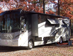
This park bills itself as a luxury resort, but we beg to differ. This is one of two "casitas" on the property. These view-blocking casas grande tower over everything and everybody. How would you like to park next to this?

Of course, we are in Moab. So, we expected to find Jeeps in this park. And, there are many.

They're all decked out for some heavy-duty four-wheeling.

There's another resident Jeep with the requisite extra large cargo trailer parked next door. Bullwinkle and Rocky felt very plain and simple in this place. They weren't surrounded by a bunch of toys.

Speaking of toys, one of our neighbors had a very noisy one. This is the view out our window as a crowd gathered to check out this old hot rod. Periodically, this neighbor would fire this noisy thing up just to attract some attention. He did!

We did manage to get away from our noisy park and do some exploring in Moab. We found a couple of geocaches close by.

The best part of our stay was spending time with friends. John and Sandy and Mike and Susan stayed at the same park. We all got away from the hubbub one evening and enjoyed some tasty local barbeque. From here, John and Sandy are off to Wisconsin, and Mike and Susan are heading to the Pacific Northwest.

Friends Jim and Sandie (and Scooter and Skittlez) stopped by the park for a few days on their way to Montana. It had been over a year since we'd met up with these two. It was great to see them again.

Jim may be a dog person, but our girl kitty warmed up to him right away!

This plaque rides on the back of Jim and Sandie's rolling home. We love it. Like our friends, we're not "dreamers". We're living!


We wish all our friends safe travels. And, we look forward to meeting up with them all again somewhere down the road. We're happy to be back on the road. But, it looks like the Freightliner gods have other plans.

More soon from our detoured destination.

Monday, May 30, 2011

Anniversary at Arches: Devil's Garden

Twenty-five years ago today we walked down the aisle. To celebrate this very special anniversary, we decided to take another walk. At 7.2 miles, the Devil's Garden Trail is the longest developed trail at Arches. (It's considerably longer than the first walk we took as husband and wife!) We got to the trailhead bright and early in an effort to avoid holiday crowds and afternoon weather, which promised to be warm and include a thundershower or two. We had researched this trail thoroughly and had a good idea what we were in for. But, the warnings at the trailhead did give us pause.

With plenty of water, sunscreen and a snack, we made our way along the trail. With the promise of eight arch sightings, this was sure to be an especially scenic hike.

The first arch on our tour was Tunnel Arch.

Paul lines up a shot of Pine Tree Arch, our second stop along the way.

Nice shot, Paul! As a ground level arch, Pine Tree gave us a lovely view. These first two arches were lovely appetizers for the main course, which was about 3/4-mile up the trail.

Landscape Arch is the longest of the park's many arches. With a span of 290 feet, it is reported to be the longest national arch in the world. The second longest is in Zion National Park. (We'll definitely check it out while we're there!) Landscape Arch's slender center is just 6 feet thick.


It was tough to capture this lovely arch in one photo. So, we tried a few seconds of video.

Most of the visitors to Devil's Garden turnaround after seeing Landscape Arch. From here on out, we expected the trekking to get a bit tougher. But, we were definitely game. We had more arches to see!

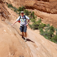
Primitive? Yep. Difficult? Uh-huh. This particularly steep section had the hikers scrambling and the acrophobes turning around. We just kept climbing.

And the view from the top of that climb was so worth it!

On down (and up) the trail, we stopped at Partition Arch, which offered sweeping views of the valley below.

Paul got in for a closer look through Partition Arch.

At Navajo Arch, a German hiker posed for an "arch within the arch" shot. We were impressed with his creativity and flexibility and gave him high marks.

Along the way we looked for the perfect "dead tree shot" to share with our hiking friends Sandy and John. This one is for you two!

The trail to the next arch had us scampering across fins in the wind. The trail was particularly hard to follow here. We looked for cairns that marked the trail, but could find none. With hikers helping hikers, we all found our way.

But, the views were magnificent!

Before reaching Double O Arch, we stepped over to the Black Arch overlook to get a distant look at this interesting arch.

Double O Arch was definitely worth the walk.

Paul bravely stepped through this arch over the very slick rock to the windy side. I opted to stay on the "safer" side.

Paul's journey to the other side of Double O Arch provided some magnificent views, like this one.

Beyond Double O Arch sat Dark Angel. We wandered down the trail to see this big ol' rock, which never did look like an angel to us, or any of our fellow hikers. It was most definitely dark, however.

We followed the trail back to Double O Arch and continued on our loop. When we encountered this sign, we began to wonder. We'd been hiking on a primitive trail for some time. Were things about to get worse? We sat and had a snack while we checked our trail guide. It assured us that if we had made it this far we could make it down this primitive route just fine.

The primitive trail provides views of a few unmarked arches. This could have been Box, Canyon or Crystal. Or, it might have been the backside of Pine Tree. Heck, we couldn't tell. But, whatever its name, it offered us a nice view.

Here's the happy silver anniversary couple at our own private arch. That's Private Arch, and it provided a great opportunity for a shot of two soon-to-be-wornout hikers.

The rest of the hike took us through Fin Canyon. We walked on top of fins....

....between fins....

and next to fins. We definitely got up close and personal with these big boys. It made for some fun and challenging hiking.

But, we did manage to stop along the way and enjoy the flowers. Nice shot, Paul!

This is one of several spots where Paul had to wait for me to negotiate my way along the primitive trail. But, can you blame me? Do you actually see a trail there?

The best spot was a place where rain had filled a large "pothole" along the trail. So many hikers had scrambled along the sandy slickrock to get around the big puddle that it was really slick. One misstep and hikers would tumble into the water. Paul made his way to safety, but I stayed back. It was very slippery! A large group of hikers from several different countries stopped to survey the situation and plan their attack. Many climbed the slippery rock. Finally, someone took off their shoes and waded through the calf-deep water. Guess what I did? That's right. After all that waiting, I waded!

After the water crossing, we made our way back toward the main trail. We took with us lasting memories of some incredible views of Fin Canyon.

Back on the main trail, we were back in the holiday crowds. While we were wandering around the fins, this busy trail really filled up.


This is the reason we got here early. It was all about getting a parking space. By the time we headed back to the Jeep, the parking lot at the trailhead was jam packed and cars were lined up along the road in overflow parking. We're sure glad we got up early and got here when we did.

What a fantastic way to spend this special anniversary! This hike amongst the arches could be our best ever.

Now, we're wondering where we'll hike on our 50th!

Friday, May 27, 2011

Canyonlands National Park

A visit to Moab puts you between two magnificent National Parks. Today, John and Sandy invited us to join them on a day trip to the park we'd yet to visit: Canyonlands. The road to the park is about 40 miles south of Moab. Once you make the turn, it's another 35 miles to the park. As we passed the entrance gate, Sandy and I pulled out our trusty copies of the National Geographic Guide to the National Parks (A most helpful book that we just picked up after seeing John and Sandy's copy.) and we set out on scenic tour of the Needles area of this nearly 338,000-acre park.

Our first stop was the Roadside Ruin. This short self-guided nature hike provided the perfect spot for us to get out and enjoy a much-needed stretch. The most notable remains are of this granary, which was built by Indians more than 700 years ago. Tucked away in a massive boulder, this well-preserved structure kept grain dry and has withstood centuries of wind, rain and weather.

Along the trail, we took in the scenic vistas. As I was lining up this shot, a woman in a big floppy hat stepped right in front of me. The things people do!

While I was dodging other park visitors, Paul went to work on our flower photo contest.

Nice job, Paul! There's a reason there aren't any of my attempts in this post. But, I digress.

Our next stop was Wooden Shoe Arch Overlook. Floppy Hat Lady followed us there, but I managed to get a clear shot of this well-named little arch.

Our next stop was Pothole Point. Another short hike lead us to gorgeous canyon views as we dodged mostly dried up "potholes".

Though the potholes look still, Sandy and I found signs of life under the surface. We spotted several baby snails and a few fairy shrimp.

The boys got into the act, too!

This was the biggest native creature we spotted on the hike. He paused for a portrait as he dodged from rock to rock in search of cool shade.

Pothole Point gave us a preview of the Needles. These pinnacles tower 400 feet above the valley and can be seen for miles.

We reached the end of the scenic road at Big Spring Canyon Overlook. Our friends Susan and Mike hiked the 11-mile Confluence Overlook Trail from here during their visit. We decided just to stand at the trailhead and enjoy the view.

Sandy found a nifty shady spot in one of the Big Canyon rocks.

We spotted some interesting formations here. This one looks a bit like a pitcher.

And, can you see the face in this boulder?

Big Canyon Overlook provided a great spot for a group photo on a gorgeous day.

As we made our way back toward the park entrance, we took a dirt road down to Elephant Hill. We spent some time climbing the beginning of a trail there and enjoyed views of rocks that resembled elephants...maybe.

Other rocks on Elephant Hill looked more like something a pachyderm might leave behind!

Sandy hiked over and between some mighty big rocks to enjoy the spectacular views.

The Needles looked magnificent.

We especially enjoyed our time on Elephant Hill. We hiked, shot gobs of photos and soaked in the views. Paul caught a moment where it looks like each of us was enjoying a different activity!

As we enjoyed a well-deserved picnic lunch at the base of Elephant Hill, we watched a couple of Jeeps and a bicyclist or two head up the off-road trail. We heard gears grinding and tires squealing, but everybody made it up to the first overlook just fine. Rocky would be so jealous!


Fed and watered, we prepared for the 90-minute drive back to Moab. After a day of enjoying magnificent views, Paul repeated the quote of the day. "Look at all these canyons! They ought to call this place canyonland!"

Indeed, they should.